
GEOINT: Measuring the Distance of an LBD Shot
March 31, 2023 · 6 min read
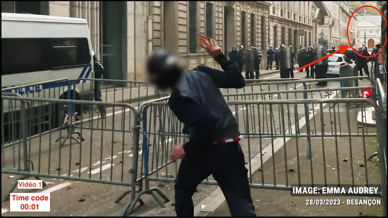
While going through our monitoring, we came across a video from the March 28 protests showing a defense ball launcher (LBD) round being fired at a protester. Emma Audrey, the journalist who filmed the video, estimates the firing distance at 5 meters. We decided to use OSINT to check whether the firing distance was indeed less than the 10 meters recommended for LBD 40 shots.
NB: We are not a politically affiliated organization; our work is solely aimed at providing verifiable, sourced information.
Defense ball launchers (LBD) are so-called "intermediate force" weapons; their use for law enforcement purposes is governed by various laws, notably the French Internal Security Code and its Article D211–19, which authorizes their use. Their conditions of use are specified in instructions no. 233500 and 4585A, but these circulars have never been made public, which makes it difficult to state a legally mandated distance for LBD shots.
There are several LBD models: those firing 40 mm diameter rounds (LBD 40) and those firing 44 mm diameter rounds (LBD 44). LBD 44 use is authorized at distances between 5 and 12 meters, but these have been gradually phased out of police and gendarmerie equipment. According to Le Monde, it appears that law enforcement now uses LBD 40 launchers, which are recommended for use at a distance between 10 and 50 meters: below that range, there is a significant risk of injury.
To measure the distance between the shooter and the target at the moment of the shot seen in the video, we need to follow these steps:
- Find the street where the incident took place
- Find the shooter's location
- Find the target's location
- Measure the distance between these two points
Step 1: Find the street where the incident took place
The tweet containing the video and its watermark indicate that the scene took place in Besançon. Aside from that, there are few distinctive elements visible in the video that would let us identify the street. However, at 00:01 we can make out what looks like an official building at the end of the street, though it would take a long time to locate without more information.
To retrace the movements of the journalist who shared this footage, we can go back to her Twitter profile to find other clips from the protest that she may have filmed around the same time, and therefore not far from where the shooting video was taken.
The video posted by Emma Audrey just before the one showing the shooting (hereafter Video 2) shows a somewhat violent interaction between another journalist and police officers.
It takes place on a square with trees, and at 00:21 we can read the name of a shop at the edge of the square where the scene unfolds.
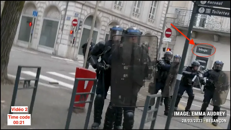
We can now search for a shop named Trilogie, located on a street corner in Besançon. Let's check this on Google Maps with the search "trilogie besançon".
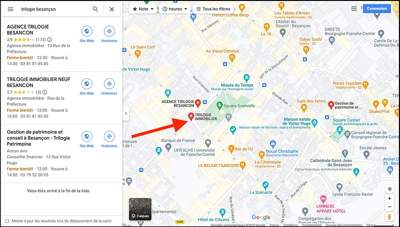
This search returns three results, but only the second one is located on a street corner as in the video and close to a park, which could explain the square and trees we see there. Let's take a closer look by heading to the street corner in front of the Trilogie agency using Street View (where the arrow points).
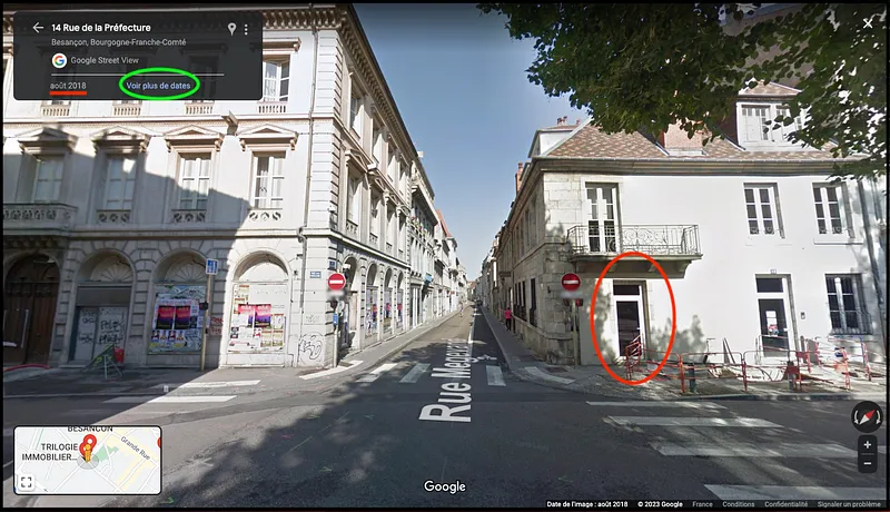
This intersection closely resembles the one in the video: circled in red, we can see the same window shape as the one bearing the "trilogie" sign in Video 2. However, the sign isn't visible here. This is likely explained by the date of the panoramic photo: in the top left corner (underlined in red), we can see it was taken in August 2018, 5 years ago. Let's see if we can find more recent imagery by clicking "See more dates" (circled in green).
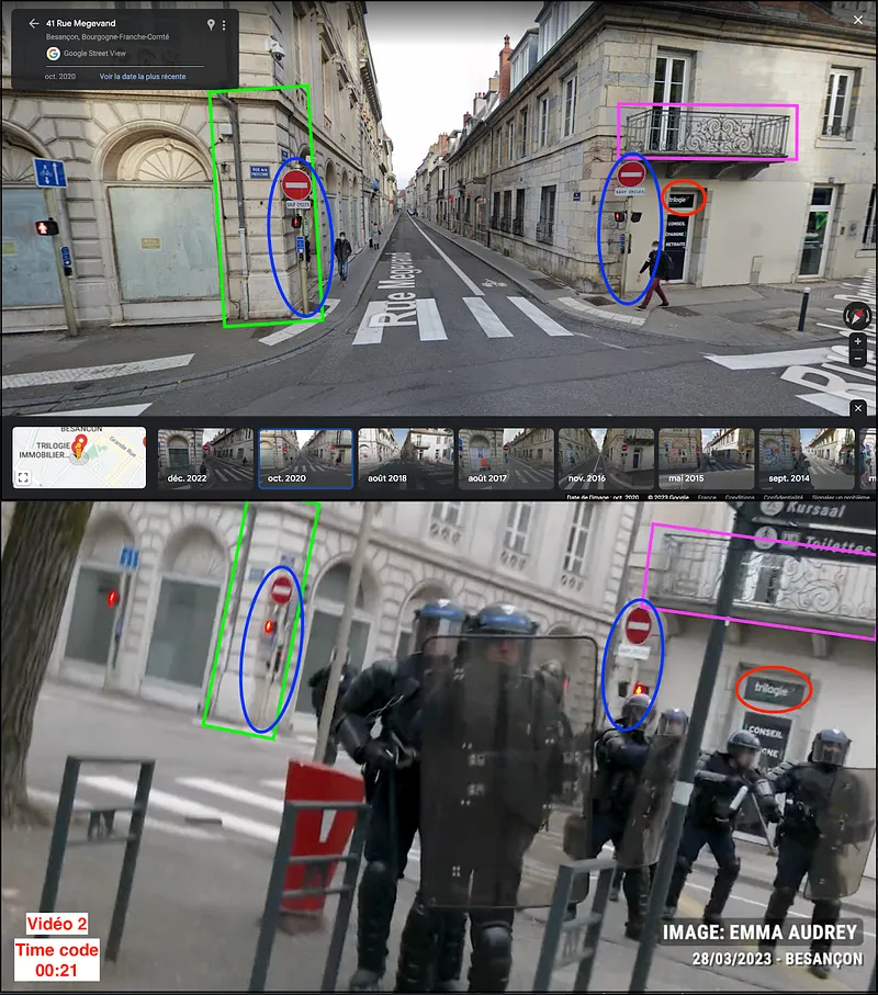
Indeed, in the panoramic image taken in October 2020 we do find the "trilogie" sign (in red), along with other elements that let us confirm with certainty that this is indeed the intersection where the video was filmed.
From there, by moving around this intersection on Street View, we find, at the end of Rue de la Préfecture, the same white building visible in the LBD shooting video (Video 1).
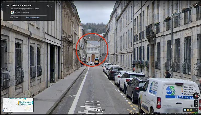
We can confirm it's the same building because we find its large rounded wooden door, its gray roof, the flag flying above it, and also the hill visible behind it. After verification, this building turns out to simply be the Hôtel de Préfecture.
This confirms that the LBD shooting video (Video 1) was filmed on Rue de la Préfecture in Besançon.
Step 2: Find the shooter's location
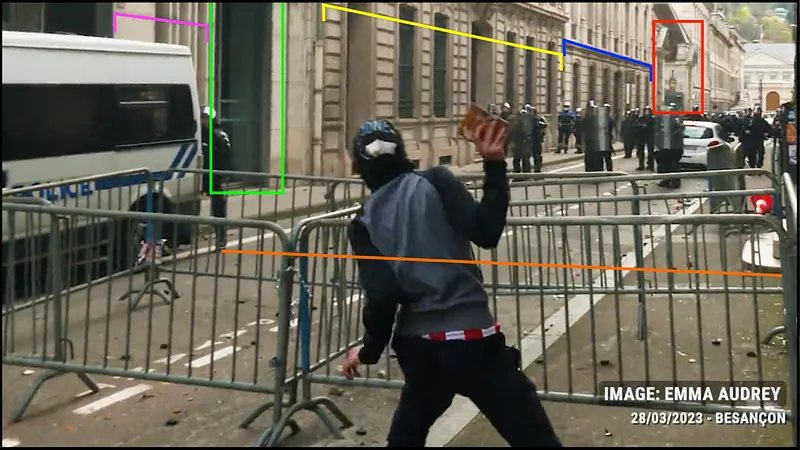
Let's go back to the first video now; we can identify several spatial markers that let us pinpoint the shooter's position precisely.
Toward the far end of the street, we can see a gate surrounded by tent-like structures (in red). Starting from there and moving away from the Prefecture, we count two different buildings (in blue and yellow), a shop window (in green) and a section of wall (in pink). The police officer is positioned at that point, on the white line painted on the ground, facing the bottom of the staircase on the opposite sidewalk (in orange).
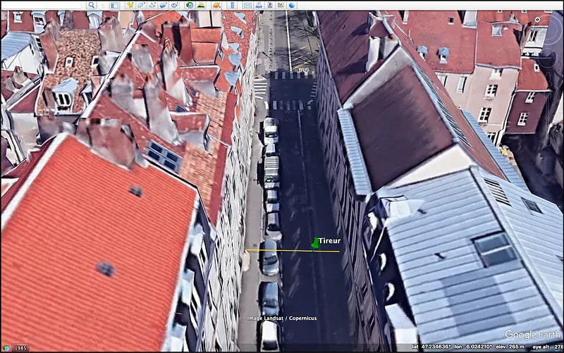
These landmarks, combined with Google Earth's 3D function, let us place the shooter's location at the GPS coordinates 47.234701, 6.024509.
Step 3: Find the target's location
In the shooting video, we can identify two elements that will let us find the exact location of the targeted protester.
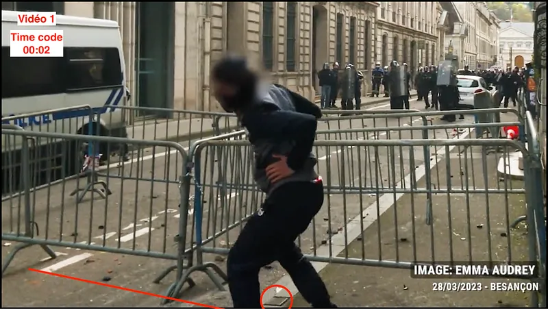
The targeted protester is standing at the edge of the sidewalk, level with the end of the "PAYANT" (paid parking) ground marking, next to the metal plate on the edge of the sidewalk.
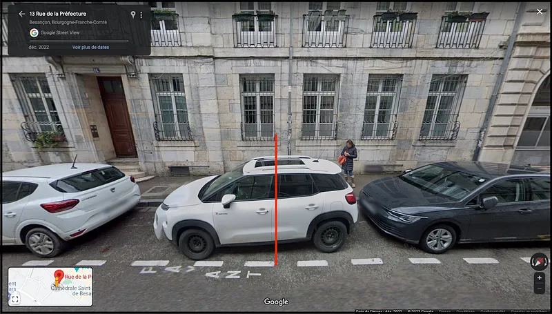
These landmarks, combined with Google Earth's 3D function, let us place the target's location at the GPS coordinates 47.234766, 6.024507.
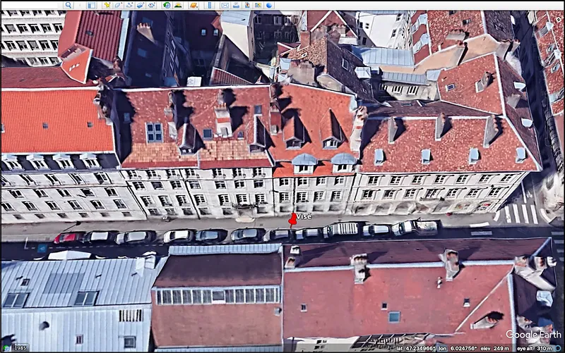
Step 4: Measure the distance
Finally, Google Earth's "Ruler" function lets us measure the distance between the two points we've placed.
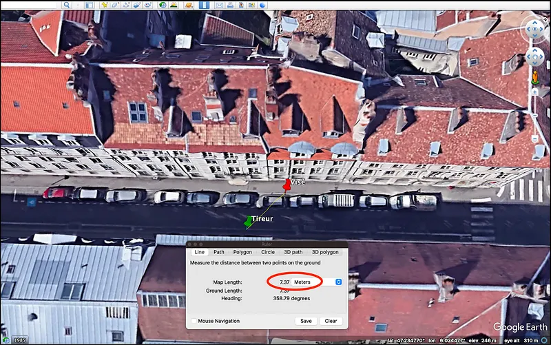
In conclusion, the firing distance between the police officer and the protester is approximately 7.37 meters.
Since the video quality doesn't allow us to verify which LBD model was used, our conclusion is as follows:
- If the shot was fired with an LBD 44 from older stock, it complies with the recommended distances.
- If the shot was fired with an LBD 40, the firing distance is below the recommended distance, even when adding a 1-meter margin of error.
This example shows how OSINT can be used to find geospatial information after the fact. To discover how to apply it to image analysis or conflict documentation, check out all of Predicta Lab's articles.
Don't miss our future newsletters !
Get the latest OSINT news, monthly recaps and product updates in your inbox.
More articles from Predicta Lab
February 6, 2024 · 2 min read
GEOINT: finding a picture taken from a plane
On February 4th, @fs0c131y shared an OSINT quizz inviting his followers to find where a picture taken from a plane was shot. Here’s a resolution found and written by Eric B., edited by Predicta Lab.
January 29, 2024 · 5 min read
GEOINT: Geolocation in the Gaza Strip
Two members of the Predicta Lab team each tried their hand at geolocating a photo of the Khan Younis evacuation taken from a Le Monde article: here's how each of them worked to reach a conclusive result.
January 25, 2023 · 6 min read
GEOINT: Documenting destruction in Donbas
Finding the locations shown in a drone video of Marinka in Donbas and reconstituting the route taken by the drone, to document the destruction caused by the Russian invasion of Ukraine.
January 17, 2023 · 3 min read
GEOINT: Geolocation using topography
This year, the transition found me staring at my screen saver for maybe a bit too long when I decided to make the most of it by geolocating the beautiful picture it was showing. So here's the challenge: geolocating my screen-saver without reverse image search!
